Monday, 8 May 2023

Iceland Day 7: My Comeuppance!

Day 7 Route (unpaved section highlighted in red)

Kattarhyggur Bridge (Cat´s Arch)

The distance between our hotels on Day 7 was just 212 kilometres or 2.5 hours away, so we decided to explore the Snæfellsnes Peninsula that afternoon. I decided to trust my memory instead of writing down the intended route. That was to be my comeuppance; I made the mistake of saying to turn onto Route 55 (to get to Route 54) instead of Route 56. Route 55 was a gravel road, albeit in very good condition. At that time, I assumed that Route 54 was all paved, so it would not be a problem. Oops, it turned out that ~ 75 km of Route 54 was unpaved and we had to drive 40 kms on a rough section before returning to paved road. Two hours on gravel roads was unanticipated and unscheduled. All I have to say for myself is that it wasn't a gravel switch-back going up a mountain through the fog without guard rails. (https://sandrawhiteway.blogspot.com/2022/12/iceland-day-4-dramatic-skies-waterfalls.html). 

Our first stop since leaving Skagafjörður was at the Kattahryggur bridge, commonly known as the Cat´s Arch.  It was one of the first concrete bridges built in Iceland along the old Akureyri Road. This road was originally used for horse-drawn carriages and later motorized vehicles. The subsequent stops had beautiful views of the Baula and Litla-Baula Mountains; which are laccoliths, a type of intrusive rock with a domed top surface and a level base. These mountains are 3.4 million years old. 

Baula and Litla-Baula Mountains from Glanni Waterfall Trail.

Coming from a place where storytelling or "spinning a yarn" is so deeply woven into our cultural fabric tends to make people appreciate the stories of other cultures. I think Iceland could take the storytelling crown. Every location in Iceland, whether it's a waterfall, a mountain or a settlement, seems to have a story associated with it that somehow incorporates gods, elves, trolls and other mythical creatures. Our next stop was to visit Glanni Waterfall on the Nordura River.  Rumor has it that Glanni is home to elves and trolls, but you are more likely to encounter salmon since the Nordura River is known for great salmon fishing. 

Glanni Waterfalls on the Nordura River

Next up was our adventure around the Snæfellsnes Peninsula. The first stop was a quick view of Eldborg Crater (translated means Fortress of Fire or Fire City). This crater presents a regular oval shape with a diameter of 200 metres and a depth of 50 metres. The surrounding lava fields were created by eruptions 5,000 to 8,000 years ago. Eldborg Crater is a 5 kilometres (3 miles) round trip hike from Snorrastaðir farm.

Eldborg Crater (Fortress of Fire)

A couple of minutes past our stop at Eldborg Crater, we began our alternative route to the north shore of the Snæfellsnes Peninsula. We transversed the peninsula via gravel roads (Route 55 and part of Route 54). The views were lovely but realistically stopping and taking Route 56 immediately would have been the sensible decision due to time constraints. In addition, the rental vehicle was small, a Kia Ceed. We saw a lovely church in a field by itself. Google maps identified it as Breiðabólsstaðarkirkja, either there are two churches with the same name or this one is called something else. Approximately 8 kilometres further we stopped to photograph a boat wreck across the water on an island. 

Breiðabólsstaðarkirkja (maybe but google maps says it is)
 
Boat Wreck on an Island 

It was along the unpaved section of Route 54 that we stopped to photograph one of the many stone cairns that we had seen. These stone cairns are ancient route markers made from lava rocks. In Iceland, these cairns (steinvarða) were traditionally placed along single-track roads to mark trails and date back to the 9th and 10th centuries. Tourism necessitated Icelandic Authorities to institute rules and rule 4 was “never dislodge stones or build cairns”. This article explains the reason and necessity for rule 4.  (https://icelandmonitor.mbl.is/news/nature_and_travel/2019/07/05/tourists_warts_removed_by_park_rangers/)

Stone Cairns (Steinvarða)

Eureka we hit pavement again as Route 56 joined Route 54. One of our stops was Kirkjufell (also known as Arrowhead Mountain in Game of Thrones) and when we arrived it was crowded. We avoided the crowds the best we could, got the photograph and continued on our way.  Kirkjufell is very picturesque and while we would have also liked to have included Kirkjufellsfoss waterfall in a photo, crowds made that impossible.  Like many beautiful spots in Iceland, I suspect the optimum times to photograph them would be sunrise and sunset and not just for the ideal light conditions.

Arrowhead Mountain in Game of Thrones (AKA Kirkjufell)

Our next major stop was Hellissandur, a fishing village dating back to the 16th century located on the north-western point of the Snæfellsnes Peninsula. Our reason for stopping here was decidedly modern; street art. Street art transformed Hellissandur's closed and abandoned buildings due to the fishery downturn into beautiful and colourful works of art.  A few pieces are showcased below.  (https://vimeo.com/311365999). 

Arctic Tern on Bird House by Ban Pesk 2019

Fears Conversation by Ban Pesk 2018

Terrors of Fróðá by Natalia Moguel, 2018

Bardur Protector of the Snaefellsnes by Camilo Arias, 2018


Crazy Birds by Ban Pesk , 2018

Bárðar Saga (Half Human Half Troll) by Nikki 10, 2018

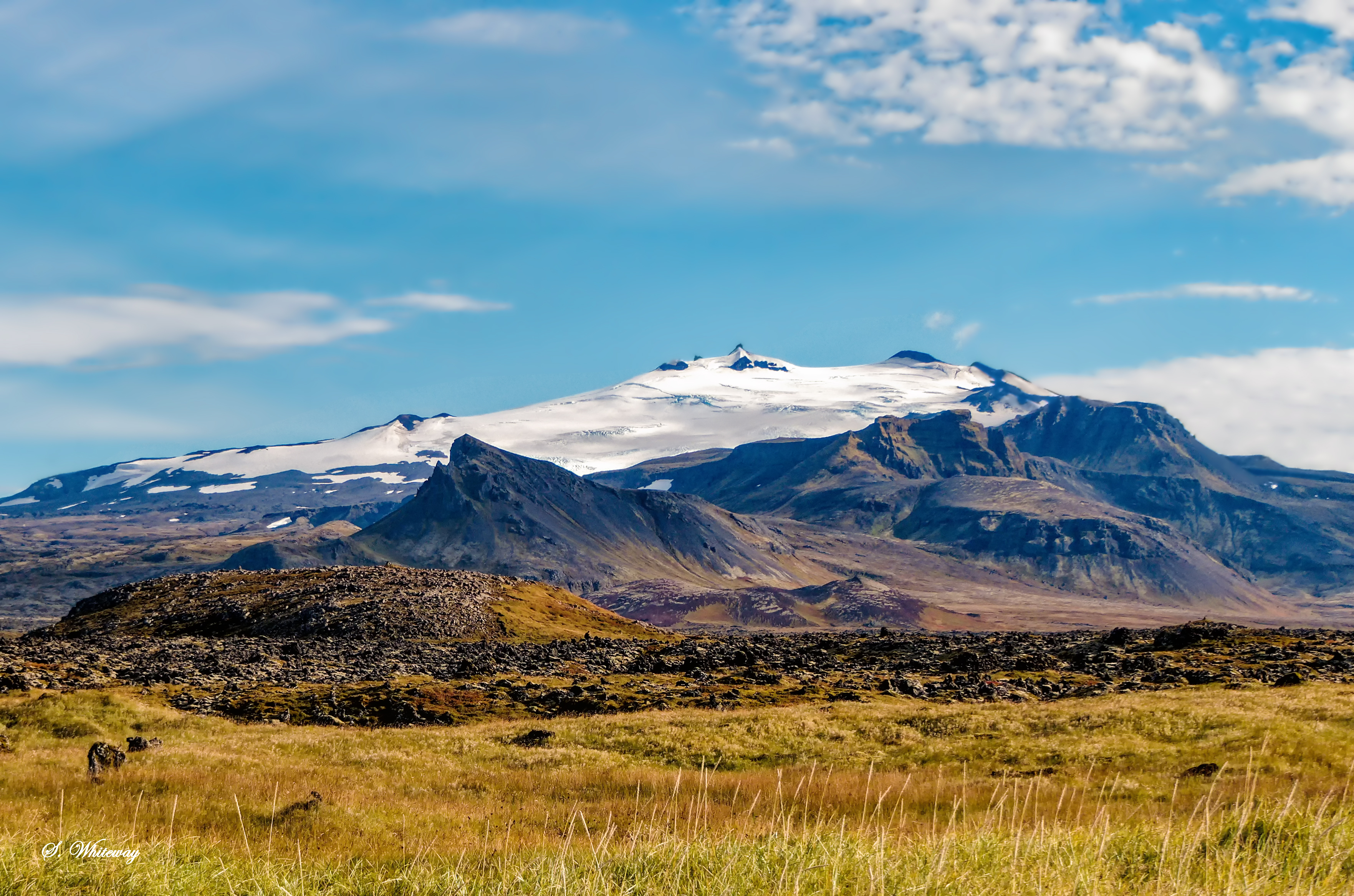
This was the point where our side trip along Route 56 caught up and the time crunch had arrived.  We headed to our hotel outside of Borgarnes to prepare for our last day in Iceland.  A few quick photo stops was all that time allowed.

View of Snæfellsjökull 

Video Clip

Sunday, 15 January 2023

Iceland Day 6: Reflections


Lake Ljósavatn, Lake of Light

Day 6 was a day of reflecting on our first 5 days in Iceland, enjoying the views as we travelled from Reykjahlíð to Sauðárkrókur. Day 5 had been an incredibly busy day, so we left later than normal and took our time as we headed towards Sauðárkrókur. The landscape along this section of the trip was not as dramatic (though still beautiful) as previous days and that provided a respite from landscape sensory overload.  The day started out as cloudy with sunny breaks and ended with rain showers, not unusual for our time in Iceland.  

Day 6 Route


Wooden Sculpture
Berjaya Mývatn Hotel
Goðafoss Waterfall and Lake Ljósavatn

Our first stop was a Lake Mývatn Viewpoint, only us enjoying a last goodbye to the Lake Mývatn area. Our second stop was a quick return to the magnificent Goðafoss Waterfall in the Bárðardalur Valley, mid morning just prior to the arrival of tour groups.  

Next up was Ljósavatn, a lake in Ljósavatnsskarð Pass near the mouth of Bárðardalur Valley. The light and weather conditions were perfect for taking pictures of lake reflections of the surrounding mountains. This was such a beautiful place, our stop was longer than normal, pure relaxation. Lake Ljósavatn was formed because of volcanic eruptions and the resulting lava blocking a depression or valley.   

Lake Mývatn Viewpoint


Goðafoss Waterfall in the Bárðardalur Valley


Eyjafjörður Fjord

From Lake Ljósavatn we traveled to Akureyri, bypassing the Vaðlaheiðargöng Toll Tunnel. We took Route 83 and 84 crossing the mountains over the Víkurskarð pass. As we were traveling in early September and had mild weather, this route was safe from snow at this time while offering a scenic view of the Eyjafjörður Fjord. Akureyri is located on the Eyjafjörður Fjord in North Iceland, known as ‘The Capital of the North’ is a mere 100 kilometres (62 miles) from the Arctic Circle.

View of Akureyri from Across the Eyjafjörður Fjord


Öxnadalur Valley

After leaving Akureyi and heading west, route 1 passes through the 30 km Öxnadalur Valley. The most prominent feature of Öxnadalur Valley is the Hraundrangi Spire in the Drangafjall ridge that has an elevation of 1075 meters (3,527 ft), 80 meters (260 ft) higher than other points in the ridge. The Hraundrangi Spire and the Drangafjall ridge are what remains of Háafjall Mountain after it collapsed in a massive rockslide near the end of the Ice Age. 

The Hraundrangi Spire in the Drangafjall Ridge

Views of the Öxnadalur Valley


Glaumbær Turf Houses

Our next stop was Glaumbær Turf Houses. In the past, everyone in Iceland would have lived in a turf house, regardless of social standing. The Glaumbær turf house was occupied until 1947, when it was declared a protected site and a farm has been located on the site since the settlement of Iceland in approximately 874. The style of the buildings at Glaumbær date back to the 18th and 19th centuries with the oldest dating back to ~1750 and the most recent from 1876-79. The Turf Houses were built out of stone, wood, and of course, turf. Turf construction evolved in Iceland owing to acute shortage of large trees (acute is an apt describe of its tree status). The buildings at Glaumbær are a thin wooden shell (the wood would have been imported), separated from each other and insulated by thick walls of turf, and roofed with a thick layer of sod. The design of the turf houses had to take into practical considerations of wet and dry periods on the turf and sod. The Glaumbær Turf Houses are well worth a stop, a step back into Iceland's history. This site has useful information of the turf house construction as well as the farm's history (https://nat.is/glaumbaer-skagafjordur-folk-museum/ ).

Glaumbær Turf Houses

Glaumbær Turf Houses

Glaumbær Turf Houses

Glaumbær Turf Houses

Glaumbær Turf Houses

From Glaumber we headed to the Snæfellsnes Peninsula.

The following websites provide additional information on various topics concerning Iceland:

Tuesday, 3 January 2023

Iceland Day 5: Variety is the Spice of Life

Day 5 Route or Variety is the Spice of Life 

Canyon Moira
Day 5 was a beautiful day from start to finish with varying vistas coupled with great weather. Waterfalls, volcanic desert, geothermal landscapes, lakes, canyons, and craters were on tap for the day. Driving between Egilsstaðir and Goðafoss, you pass through a landscape change around every corner making this one of the most beautiful parts of our Iceland Journey.

Canyon Moira

Our first stop after leaving Egilsstaðir was the Canyon Moira, a beautiful canyon just off highway 1, that has little or no signage. It is a short hike to the canyon bridge, through a gated trail that is accessible but lifting the latch on the red gate. Now I had seen beautiful pictures of blue-green water in Canyon Moira but as the Jökulsá á Dal, is a glacial river, mud and silt are a normal occurrence as well. In fact, Jökulsá á Dal was the muddiest of Icelandic rivers, carrying approximately 112 tons of clay and sand to the ocean daily. While the Kárahnjúkar Hydroelectric Power plant has reduced the amount sediment and silt entering the river, my visit shows that significant amounts are still transported via the river to the ocean, depending I suspect, upon the amount of water released from Kárahnjúkar dam on any day.

The pedestrian Bridge over the Jökulsá á Dal River at Canyon Moira

Rjúkandafoss

Next up was another series of waterfalls collectively know as Rjúkandafoss. It is one of the tallest waterfalls in Iceland with an overall height of 139 meters (456 feet) when including all in the series of the waterfalls, thus making it easily visible from the road.

Rjúkandafoss along Highway 1

Alternate View of Rjúkandafoss 

Volcanic Desert

View from Parking de la Chaise Blanche, North East Highlands

Our rental vehicle was a car so travel along Iceland's infamous F roads was forbidden and a car would have been unsuitable to that environment. While the Ring Road technically does not traverse the Highlands of Iceland, driving from Egilsstaðir to Reykjahlíð you pass through a small offshoot of Iceland's Highlands (Northeast Highlands). The main portion of Iceland's Highlands are located on a sparsely inhabited plateau, an area that is barren, devoid of life and is a volcanic desert. Do not get me wrong there are Highland areas I would love to see, next time with the aid of a high clearance 4x4 and more time.

Our first stop was at the "Parking de la Chaise Blanche". It is probable that the large white chair has "bite the dust", having succumb to the harsh environment in which it was placed. The surrounding area was so devoid of life it is easily understandable why NASA conducted moon training missions in Iceland. Water infiltrates the ground so quickly in this type of environment that it is unavailable for plant growth resulting in a surface of grey, black, or brown earth, lava, and volcanic ashes. While the landscape may at first seem sparse, it is an incredibly diverse landscape that includes glaciers, geothermal hot springs, spectacular ice caves, stunning waterfalls and is an active volcanic landscape. Its this incredibly diverse, fascinating, and unique landscapes that so intrigues visitors to Iceland.  

Volcanic Desert Landscape of the North East Highland

A mere 5.6 kms (3.5 miles) down the road is the Beitarhúsið cafe. The building was what caught our interest, but the warning sign was the revelation. In the parking lot, a large government sign warning about continuing down the road as it was a F road and 4x4's were required. Additional insurance was strongly recommended such as gravel protection and a Super Collision Damage waiver. Also, it noted that most rental cars do not have an insurance for the undercarriage damage and undercarriage damage can occur on the F roads. We carried full insurance and are very thankful we did as two weeks later, many cars were damaged from high winds that pummeled northeast Iceland. In one of the photos in the linked article, most of the signs I mentioned above are missing and cars are severely damaged (https://www.ruv.is/frett/2022/09/26/worst-storm-in-living-memory).

Beitarhúsið

 Dettifoss and Selfoss

Dettifoss, Selfoss, and Hafragilsfoss are located on the Jökulsá á Fjöllum River which flows from the Vatnajökull glacier and is in the Vatnajökull National Park in northeast Iceland. We did not visit Hafragilsfoss. Dettifoss is one of Europe’s most powerful waterfalls, second actually in terms of water flow. While you can visit both sides of the river, the west side road is paved. We attempted the east side but decided it was a not safe to drive for the vehicle we had rented. The east side was in rough shape and turned out to be the roughest unpaved road we tried in Iceland. The west side road (Dettifoss Road) is paved and as such will have more tourists. We still got great photos and were not subjected to hoards of tourists. 

Returning to Route 1 along Dettifoss Road, you could see the steam coming out of the vents at Hverir Geothermal Area, our next stop.

Dettifoss from West Side

Selfoss from West Side

Hverir Geothermal Area

The Hverir Geothermal Area is at the foot of Námafjall mountain, part of the Krafla volcano fissure zone. Hverir is one of the most active geothermal areas in all of Iceland, so expect, smoking fumaroles and boiling mud pots all surrounded by sulphur crystals of differing colours. And of course, the overwhelming smell of rotten eggs. Hverir is atop of the Mid-Atlantic Ridge; the boundary where the North American and Eurasian tectonic plates meet and separate. 

The gas and heat observed at Hverir is generated approximately 1,000 meters (~3200 feet) below the surface, where cold groundwater seeps down to the magma layer and is superheated to above 200 °C (390 °F). Obviously sticking to marked trails is essential for safety reasons. There is a hiking trail up the Námafjall mountain. Due to timing constraints, we were unable to hike it, but I suspect it will provide some interesting views of Hverir. 

Námafjall Mountain and the Hverir Geothermal Area

Bubbling Mud Pools
Smoking fumaroles (no not manmade)

Hverfjall

Hverfjall volcanic crater is a tephra explosion crater or tuff ring volcano, a kilometer (3280 ft) in diameter and about 396 metres (1300 ft) high. The volcano which erupted in 2500 BP is part of the Krafla fissure swarm. Hverfjall is a popular hiking destination and based on our experience timing is critical if you wish to hike it. When we arrived at the parking lot, it was full of both cars and tour buses. The hiking trail around the crater was crowded. We decided to head onto our next destination a little further down the road. 

Hverfjall Volcanic Crater


The Skútustaðagígar Pseudo Craters 

The Skútustaðagígar pseudo craters are a natural phenomenon that occurs because of hot lava flowing over cool, wet grounds resulting in the pressurization of the earth from flowing lava, rather than being caused by the volcanic eruptions. Steam becomes trapped under the lava, producing extreme pressure. Steam explosions are triggered when pressures exceed a certain threshold, creating depressions in the ground known as pseudo craters. Pseudo craters are a rare phenomenon found only in Iceland, Hawaii, and the Azores islands. The biggest pseudo craters in Iceland are the Skútustaðagígar pseudo craters in the Mývatn area in North Iceland and were formed during the eruption of Lúdentaborgir and Þrengslaborgir around 2,300 years ago.

Skútustaðagígar Pseudo Craters

Mývatn Lake and a View of Several Pseudo Craters

Goðafoss and Geitafoss


As the day 5 ended we visited the beautiful Goðafoss (Waterfall of the Gods) located on the Skjálfandafljót River, the fourth-largest river in Iceland. It is one of the most spectacular waterfalls in the country, falling from a height of 12 meters (39 feet) over a width of 30 meters (98 feet). Of course, like many sites in Iceland there is a related legend (https://glacialexperience.is/the-historical-godafoss-waterfall-in-north-iceland-the-waterfall-of-the-gods/.). While Geitafoss is the smaller downstream sibling to Goðafoss, it is located on turbulent section of the river making it small but mighty. The name, Geitafoss or Goats' Fall stems from a farmer who herded his sheep and goats near this location. 

Goðafoss in the Early Evening

Geitafoss the smaller downstream waterfall from Goðafoss


Monday, 26 December 2022

Iceland Day 4: Dramatic Skies, Waterfalls, Breiðdalsheiði Pass and Fjarðarheiði Pass

Route 95 the Road between Breiðdal and Skriðdal Valleys.

Day Four Route: 
Höfn í Hornafirði to Egilsstaðir

Dramatic skies, fog, no rain and no sheep (they must have been hiding) was the fare for day four. We would travel from Höfn í Hornafirði to Egilsstaðir with a side trip to Seyðisfjörður. A 280 km trip with several waterfall stops.

Brunnhorn and Vestrahorn Mountains

Our first couple of stops were to view the beautiful Brunnhorn (locally known as Batman Mountain) and Vestrahorn Mountains along Route 1. The clouds and fog add a touch of drama to these mountains which are composed of iron and magnesium rich gabbro rock, leading to their dark and jagged appearance. Eystrahorn (no photo) across the bay from Brunnhorn and Vestrahorn is the third of ‘Horned’ mountains found on the Stokksnes and Hvalnes peninsulas in East Iceland. The trio of mountains dates back 8-11 million years. Unlike most mountains in Iceland, the horned mountains are composed of gabbro rock resulting from the slow cooling of the magnesium and iron-rich magma, trapped beneath the earth, forming a holocrystalline mass. These mountains are part of the Klifatindur mountain range. Most other mountains in Iceland are composed of basalt, or Landmannalaugar (rhyolite). I am still not going over to the 'dark side' with my geologist and geological engineering friends, no matter how much I loved Iceland's geology.

Brunnhorn Mountain (AKA Batman Mountain) with the "almost" visible batman symbol next to Vestrahorn Mountain

Fremstifoss and Skútafoss on the Þorgeirsstaðaá River

Fremstifoss on the Þorgeirsstaðaá River

Next up was a couple of waterfalls, along what was now an extremely wet trail with running streams from the several days of heavy rains. Fremstifoss waterfall is the first along the trail leading to nearby Skútafoss. They are located near the red chair and no we did not stop to photograph it. We have our own Canadian versions. It did bring a smile considering it was the stop with the most people that morning and everyone was having a fun.  

At Fremstifoss, there are the remnants of a small power plant built in 1966 including a small dam on the Þorgeirsstaðaá River. Further up the river is Skútafoss, a double waterfall which based on research (once we got home) has an associated cave. We never walked all the way to it. We had inadvertently interrupted a call of nature and thought it was polite to make a strategic retreat and not cause the person any additional embarrassment. We are Canadian, and well there is a distinct lack of trees in the area. A little further up from Skútafoss, there is a third waterfall Innstifoss so this would be the perfect place for a stop with an easy hike during a road trip.

Skútafoss

Barkináfoss

Barkináfoss is a small waterfall located on the northern shore of Álftafjörður (swan fjord) of the East Fjords (Eastern Region) of Iceland. It's located between Höfn í Hornafirði and Djúpivogur (~22 km west of Djúpivogur).  

Barkináfoss

Lighthouses


Streitisviti Lighthouse
Hvalnes Lighthouse

We made two quick lighthouse stops on day four, mostly to stretch our legs and enjoy the scenery.  The lighthouses almost seem out of place for our day four travels due in part to the beautiful waterfalls, volcanic mountains, and dramatic skies that we encountered. Our first lighthouse stop was a bright orange lighthouse (Hvalnes Lighthouse) on the south coast on Cape Austerhorn. The views from near this lighthouse are magnificent. The second lighthouse was Streitisviti Lighthouse and once again lovely views, but the best views were up the road and around the corner enroute to Breiðdalsvík, a mere 10 kms from the Streitisviti Lighthouse.  

Route 1 between Djúpivogur and Breiðdalsvík

Djúpivogur and Breiðdalsvík are two small fishing villages in the Southern East Fjords region approximately 60 km apart along route 1 with a combined population of ~500. The mountains between these two villages are breathtaking. Located near Djúpivogur is Mt. Búlandstindur; a 1069-meter-high basalt mountain approximately 8 million years "young" and situated between the bays of Berufjörður and Hamarsfjörður. Just outside of Breiðdalsvík is Meleyri, a beautiful long black sand beach. The mountains around Breiðdalsvík are also lovely surrounding the Breiðdalur valley. 

Mt Búlandstindur from the Hamarsfjorður side

Mountains near Breiðdalsvík taken from Meleyri Beach

Breiðdalsvík taken from Meleyri Beach with Mt Snæhvammstindur in background

Route 95 or Route 1

Views from Route 95 in the Breiðdalur

Route 1 takes you along the coast with small towns and fjords. Route 95 tranverses Breiðdalur Valley, the largest valley in the East Fjords region. Hubby decided to do planning and as we passed Djúpivogur, he stated we will be taking Route 95 and to be honest I had done minimum research for the day's trip. Not sure if that was my first mistake as I normal do most of the planning but off we went along Route 95. The valley is incredibly beautiful and was a change of scenery from the coast that we travelled for the last couple of days. The Breiðdalur Valley is covered is grassy thus making the area perfect for sheep farms, of which there were several, but I guess the sheep were hidden away that day (not complaining).

Fell Horse Rental is along Route 95, and we had a short stop while horses were herded across the road. This was the first people we encountered since turning off onto the route 95, 5 kms back. The next time we would see anyone was as we were starting to transverse the mountain pass Breiðdalsheiði, ~30 kms later. So, this route is not well travelled, and it may be because at ~15 kms, it became a reasonably groomed gravel road with some potholes. This was unexpected as during our trip planning most information had stated that 2-digit roads (95) were paved and well-maintained roads. My second mistake may have been to suggest we keep going rather than turn back unless the road got worse, it didn't. We have sections of paved roads in Newfoundland and Labrador that are in worse shape that this one and the scenery was incredible, so we continued.

Western Mountains in Breiðdalur Valley
  
View of North-Eastern Side of Breiðdalur Valley

Last Stop before Breiðdalsheiði Pass Complete with a Switch Back, No Guard Rails and Dense Fog

The last stop before we traversed Breiðdalsheiði Pass was also our last chance to safely turn around. While I was not driving, it was still nerve racking being a passenger. The rock road wasn't bad, but the dense fog combined with a switch back and no guard rails was the scary part. Of course, you didn't appreciate the impact the fog was going to have traversing the Breiðdalsheiði Pass at this spot. If we had, we may have turned back, I am glad we didn't. As we neared the foggy part, we passed a a car with the passenger filming or live streaming their trip down the Breiðdalsheiði Pass. Once we reached the summit and started down the valley to Egilsstaðir, the fog lifted and the skies slowly lighted. I must admit the Breiðdalur Valley portion was much more beautiful than the rest of the trip to our hotel in Egilsstaðir from Breiðdalsvík.  Or maybe it was that the adrenalin rush had dissipated.  

Enroute to Egilsstaðir from the Breiðdalsheiði Pass

Fjarðarheiði Pass to Seyðisfjörður

After a quick check-in at our hotel, we went to Seyðisfjörður, through the Fjarðarheiði Pass. The Fjarðarheiði Pass was still foggy but not as dense fog as was in the Breiðdalsheiði Pass. Not unlike a normal early morning trip out around the bay in Newfoundland and Labrador. The road was paved and had guard rails. We did a quick walk in the picturesque village of Seyðisfjörður which is the closest Icelandic port to the Faroe Islands and Europe. Enroute back we stopped at Gufufoss Waterfall. The route to Seyðisfjörður has several lovely waterfalls, coupled with the numerous hiking trails in the Egilsstaðir area makes this a good area for a multiday stop.  

Seyðisfjörður

Gufufoss Waterfall on Route 93 to Seyðisfjörður


The following websites provide additional information on various topics concerning Iceland:

https://www.ntounas.gr/brunnhorn-the-batman-mountain/

https://guidetoiceland.is/connect-with-locals/nanna/the-three-horny-mountains-of-east-iceland-1

https://glacialexperience.is/the-eastfjords-of-iceland-are-dotted-with-beautiful-little-villages-and-hidden-secrets/

https://www.east.is/en/destinations/communities/breiddalsvik

https://guidetoiceland.is/travel-iceland/drive/seydisfjordur